Michnaf specializes in the development and maintenance of GIS systems for companies, authorities and organizations.
GIS system is a perfect technological solution that centralizes the spatial management in the organization and saves valuable time and resources.
We offer an advanced and convenient solution that concentrates the management of infrastructures and assets in a single organizational database. Geographic information technology, which saves precious time and resources, and provides monitoring and control over all terrains, assets and infrastructures in the organization.
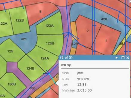
The GIS system – an organizational tool for the management of terrains and assets in geographical information layers over a map and a computerized digital database. Michnaf’s GIS system includes a friendly and convenient interface that enables easy and quick presentation, analysis and sharing of information inside and outside the organization. The system enables accurate documentation of infrastructure deployment, project planning in open and built terrains, as well as supervision and control of the operation of systems, teams and equipment.